Satellite Data in Agriculture: Turn Images Into Valuable Insights

Farming has come a long way from its traditional roots. Modern-day agriculture involves data-driven decisions, from predicting weather patterns to analysing crop yields. One of the most significant advances in recent times has been the use of satellite data in agriculture. In this blog post, we will take a closer look at Farm21’s premium satellite offering, and how it can benefit agri professionals. We will also explore the advantages of using satellite imagery for farming, and why it has become such an essential tool in modern agriculture.

The Use of Satellite Data in Agriculture
The use of satellite data in agriculture has revolutionised the way we understand and manage our fields. The history of satellite data in agriculture can be traced back to the 1970s when the first Landsat satellite was launched by the United States. This satellite provided the first high-resolution images of the earth’s surface, which could be used to monitor crop health, soil moisture, and other important agricultural parameters. Since then, numerous other satellites have been launched with increasingly advanced imaging capabilities.
Today, satellite data is used extensively in agriculture for a variety of applications. One of the most important uses of satellite data is for crop monitoring. Satellites can provide accurate and timely information about crop growth and health, allowing farmers to make informed decisions about irrigation, fertiliser application, and other management practices.
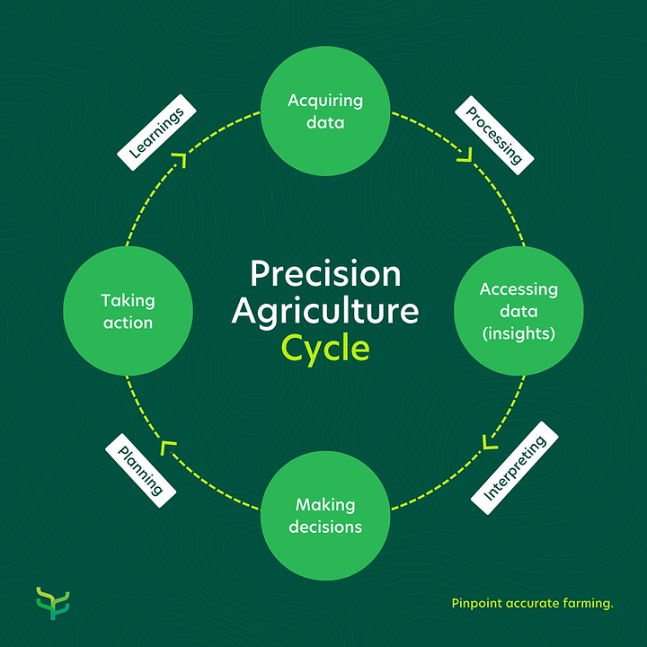
Stemming from the above, satellite data plays an important role in precision agriculture, where farmers use detailed information about their fields to optimise their operations. This includes using satellite data to create detailed maps of soil types, nutrient levels, and other important parameters. This information can be used to tailor management practices to specific areas of the field, leading to increased efficiency and reduced waste.
Overall, the use of satellite data in agriculture is transforming the industry, allowing farmers to make data-driven decisions that lead to increased productivity and sustainability. As satellite technology continues to improve, it is likely that the use of this data in agriculture will become even more widespread and impactful.

Overview of Farm21’s Premium Satellite Offering
Farming has always been a challenging industry, with unpredictable weather patterns, pests, and diseases making it difficult for growers to optimise their yields. Adding to that, modern challenges like climate change, an increasing global demand for food and soil degradation adds even more pressure on the agri industry. However, advances in technology give farmers access to powerful tools that allow them to make data-driven decisions to improve the quality and even the quantity of their crop yields in order to overcome these challenges.
Farm21 is a Dutch Ag Tech company specialising in providing pinpoint accurate data for growers, crop advisors and agricultural researchers. Our smart data platform pulls information from multiple sources like weather applications, soil moisture and temperature sensors as well as satellite images to give users real-time insights and a complete overview of what is happens in their fields.
Farm21’s premium satellite offering is a powerful tool that gives farmers easy access to high-resolution satellite imagery of their fields and crops. This imagery can be used to identify areas of the field that may be experiencing stress or other issues, as well as to monitor crop growth and yield potential throughout the season.
One of the key features of Farm21’s premium offering is the higher resolution imagery that is available. Compared to the free plan (which offers 10m x 10m resolution), users get 3m x 3m resolution images. This allows growers to see more detail in their fields and identify potential issues that may not be visible with lower resolution imagery. In addition, the premium offering also provides more frequent updates, giving users access to near-real-time field information.
Compared to Farm21’s standard satellite offering, the premium offering provides farmers with more detailed and up-to-date information about their crops. The standard offering still provides valuable insights, but the premium offering is better suited for those opting for maximum data-density.
Overall, Farm21’s premium satellite offering is a powerful tool that can help farmers optimise their yields and make data-driven decisions about their crops. With high-resolution imagery and frequent updates, growers can stay on top of crop growth and identify potential issues before they become major problems and go from reactive to proactive farming. Find a time to meet with one of partnership managers to get started:
Turning Images Into Insights: What the Different Indexes Can Tell You About Your Crops
Different types of satellite indexes are used to analyse a fields and provide growers, researchers and crop advisors with valuable information about their crops. Among the most commonly used indexes are NDVI, NDRE, and NDMI. Let’s explore each of them in more detail:
NDVI
The Normalised Difference Vegetation Index (NDVI) is a measure of the amount and vigour of live vegetation in a given area. It is calculated using the difference between near-infrared (NIR) and red reflectance values from satellite which helps to identify areas with higher levels of photosynthetic activity. The formula for calculating the Normalised Difference Vegetation Index is as follows
NDVI = (NIR – Red) / (NIR + Red)
(NIR = Near Infrared reflectance and Red = Red reflectance)
The resulting NDVI values range from -1 to +1, where negative values indicate water bodies or other non-vegetated surfaces, values close to 0 indicate sparse or stressed vegetation, and values close to +1 indicate dense and healthy vegetation.
NDVI value lies in providing an accurate and timely indication of plant growth and health, which can help farmers and land managers to make informed decisions to manage crops more efficiently. For example, NDVI can be used to identify areas of a field that are experiencing stress due to water or nutrient deficiency, pests or diseases, or other environmental factors. By monitoring NDVI over time, farmers can track changes in vegetation health and respond quickly to any issues that arise.
For example, growers can use NDVI data to create maps of their fields that highlight areas with higher or lower vegetation health. These insights can then be used to vary the rate of fertiliser or water application so that crops receive exactly the amount they need to grow most efficiently. When used effectively, NDVI can guide management decisions that leads to profitable crop yields, reduced inputs, and lower environmental impact.
NDRE
The Normalised Difference Red Edge (NDRE) is a vegetation index that uses the difference in reflectance between near-infrared (NIR) and red-edge (RE) wavelengths of light to measure the amount of chlorophyll in plant leaves. The red-edge wavelength range is particularly useful for assessing plant health, as it is sensitive to changes in plant pigments and leaf structure.
By measuring the amount of chlorophyll in plant leaves, NDRE can help farmers and land managers to identify areas of a field that are experiencing stress due to water or nutrient deficiency, pests or diseases, or other environmental factors. In short, NDRE will point you to the stressed crop, so you can further investigate the cause of the low chlorophyll content and take the necessary action to minimise the damage.
NDMI
The Normalised Difference Moisture Index (NDMI) detects moisture levels in vegetation using a combination of near-infrared (NIR) and short-wave infrared (SWIR) spectral bands. NDMI is a reliable indicator of water stress in crops, and it can be used to identify areas of a field that may be experiencing drought or other types of water stress.
It is important to note that NDMI values can vary throughout the growing season, as the reflectance of plants changes with each phenological stage. In addition, there is a correlation between NDMI and NDVI. When NDMI values indicate water stress, NDVI values are typically significantly lower than average, confirming the water stress condition.
For example, in a vineyard, NDMI can be used to monitor soil moisture levels and to identify areas of the vineyard that may be experiencing drought stress. By adjusting irrigation practices in response to NDMI readings, vineyard managers can optimise grape quality and yield while minimising water use.
Satellite Data and Precision Farming
Learn more about incorporating satellite data in your day-to-day work as a farmer, advisor or agriculture researcher in the video below:
How to Get Started With Farm21’s Premium Satellite Offering
Accessing our premium satellite data is effortless and affordable:
- Start by creating a free account on our data platform. After drawing in your fields, simply request the premium satellite service by emailing [email protected] and we will activate it for you.
- If you already a customer with existing fields, and you wish to upgrade to premium, you can request in the same way as above.
- The cost is €10 per ha per year and you’ll receive higher resolution and more frequent images.
- You can easily access the data at any time on Farm21’s smart data platform.

Conclusion
Farm21’s premium satellite offering is an excellent solution for farmers who want to improve their agricultural practices, crop quality and yield. The real-time data provided by Farm21’s premium satellite offering can help farmers optimise their use of resources, reducing waste and increasing profitability.
This technology is a significant step forward for precision agriculture and sustainable farming practices, and we can expect to see more farmers adopting these tools in the years to come. By investing in Farm21’s premium satellite offering, farmers can gain a competitive edge and contribute to a more sustainable future for agriculture.

