FREE Precision Agriculture’s Ultimate Cycle: The 4-Stage Handbook
More than 60 pages of precision farming knowledge are included in the handbook
In this handbook, you will learn the following:
Introduction
Precision Agriculture’s Ultimate Cycle: The 4-Stage Handbook
Written by Alrie Vellerman and Dana Gelerter
The agricultural landscape has significantly expanded and changed over the last 50 years. One of the world’s oldest industries must embrace and utilise technological innovation if it wants to flourish despite the pressures it currently faces and will face in the future. Traditional farming methods are simply insufficient to yield enough produce to keep up with the rise in global food demand. Combined with environmental pressures like climate change, soil degradation and water scarcity, growers and producers are forced to explore innovative ways to manage their production.
Precision Agriculture was initially theorised in the 1980s by Dr Pierre Robert, a pioneer in the field of precision farming principles. The idea was to use technology and equipment to spend resources where it is the most needed in the field. With the rise of modern computer technology, precision farming became more exact and could be rolled out on a bigger scale and applied to bigger farming operations.
“Precision farming, or smart farming, is the practice of using data to optimise agricultural production, despite variable circumstances. It is a way of farming where every specific crop gets the right treatment, at the right time and in the right place. To do that, you need to know the precise details of your crops and fields.” – Jits Riepma, Agricultural Data Analyst
Precision Agriculture works in a cycle and can be broken down into four stages: 1. Acquiring data 2. Accessing data 3. Making decisions 4. Taking action
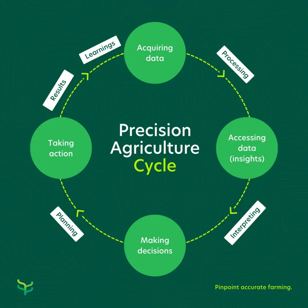
We have noticed that growers, researchers, and crop advisors often need help getting started or understanding how to build and maintain a precision farming operation. In this handbook, you will find an extensive explanation of how to successfully get started and follow the four-stage cycle to elevate your business. You’ll also find case studies and practical examples of growers that implemented precision farming principles on their farms, as well as how it benefited them.
Chapters
1. Acquiring data
Precision farming can be seen as a cycle that consists of four main stages — The first step at the beginning of the cycle is data acquisition. With the availability of a wide range of data and more information than ever before, field details can be translated into insights, and these insights can help farmers, crop-advisors and researchers to manage their operations better. Various data collection methods are available to measure, capture, and track information that will lead to better decision making. In this part of the handbook you’ll read more about the following:
- An overview of what data acquisition entails
- The different ways in which data can be collected
- Precision farming’s most important metrics to collect (and what they mean) including soil information, soil moisture content, soil temperature, absolute and relative humidity, satellite information and air temperature
- Choosing the best soil moisture sensor to gather field and crop data
- Who can benefit from soil moisture sensors
- An in-depth comparison of 5 soil moisture sensors
- An overview of Farm21’s soil moisture sensors
- An easy, efficient, and affordable way to collect data with smart data platforms
Overview of what data acquisition entails – Click here to read
Choosing the best soil moisture sensor to gather field and crop data
In its essence, soil moisture sensors use an electrical current to detect the presence of water in the soil. These sensors then send the information to a computer that displays the results digitally. With technological advancements and the evolution of precision agriculture, current soil moisture sensors have developed in such a way to provide much more than just soil moisture measurements. They’re often paired with a comprehensive digital data platform, so users have access to a range of valuable field, crop and weather data. Insights from this data can lead to better decision-making resulting in optimal use of resources and yield increases.
Who can benefit from soil moisture sensors?
Soil moisture sensors hold many benefits for a multitude of stakeholders. Growers, researchers, crop advisors, distributors and co-ops can use this smart farming tool to benefit their operations in different ways:
- Growers – By knowing their exact crop and field conditions growers can make better decisions with regards to resource usage and timing. This ultimately leads to maintaining optimal growing conditions, resulting in increased yields and healthier crops.
- Crop advisors – With a constant stream of real-time field insights, crop advisors remain up to speed on clients’ field intelligence, whether they’re in the office or on the road. Quick access to accurate information allows users to make data-driven decisions.
- Researchers – When it comes to running trials across various trial sites, agriculture researchers can now remotely monitor trial sites and receive a constant stream of consistent and accurate data. Having data from soil sensors can save time, money and resources.
- Distributors and Co-Ops – Whether already a distributor of Precision Ag tools or wanting to expand their offering to stay with the times, distributors and co-ops can benefit from adding high-quality soil sensors to their portfolio. Benefits include return on investment and long-lasting client relationships.
An in-depth comparison of 5 soil moisture sensors
- Arable – Arable was founded in 2014, with its headquarters in the USA. They have a global reach and operate in 30 countries. They produce the Mark2 sensor and data on rainfall, crop water demand, water stress, microclimate, canopy biomass, and chlorophyll levels are available through their smart data platform.
- CropX – CropX is based in the US and operates worldwide. Their first-generation product went to market in 2017. They offer an integrated hardware and software system with a suite of decision and planning tools based on continuous monitoring of soil and crop conditions. Their sensors send the collected data to the Cloud and send back advice and insights.
- Sensoterra -Sensoterra is a Dutch company founded in 2015. They focus mainly on water management solutions and their product range includes single and multi-depth soil moisture sensors. Users can access data through the Sensoterra app or a platform from one of their Integration Partners.
- Sentek – Sentek was founded in Australia and has been around since 1991. They design, develop, manufacture, support and globally distribute products for measuring and managing soil moisture, salinity and temperature. They have 6 soil moisture probes included in their offering, including the Enviroscan that can measure from 0.5 up to 40m.
- Farm21 – Farm21 was founded in 2017, and based in the Netherlands. We entered the market with the FS11 soil moisture probe and released the FS21 sensor at the beginning of 2022. We’ve expanded to over 15 countries and users can access data from their wireless soil sensors, weather, satellite, and scouting information through their data platform.
To choose the best soil moisture sensors, we looked at client reviews, business websites, and other credible online sources. The below table compares the leading brands:
| Easy hardware installation | Hardware features | Platform features | Product Support | Pricing per sensor | Software licence per sensor per year | |
| Farm21 | 5/5 | – Capacitive soil moisture 3 depths – Soil temperature 2 depths – Air temperature in canopy – Air humidity in canopy – Build-in global GPS – Rechargeable battery through USB-C – Extendable/modular – NB-IoT/LTE-M/2G | Satellite (free) – Water risk map – Growth risk map – Crop stress map – Scouting app – Irrigation advice + water retention curve – Data sharing – Excel and API exports | Farm21 and local partners like cooperatives or crop advisors | 295 euro | 63 euro |
| Arable | 2/5 | – Near-infrared measurements – LTE-M | – Evapotranspiration calculation – Crop stress calculation | Arable | 1500-2000 euro | Unknown |
| Cropx | 3/5 | – Multi depth soil moisture – Multi depth soil temperature – EC – 3G | Satellite (paid) – Biomass – Irrigation advice – Sensor statistics | CropX | 999 euro | 285 euro |
| Sensoterra | 5/5 | – Single depth resistive soil moisture. Note: resistive measurements can be inaccurate – LoRa | – Limited, focus on API | Sensoterra | 350 euro | Unknown |
| Sentek Drill & Drop | 2/5 | – Multi depth soil moisture – Multi depth soil temperature – Optional multi depth soil salinity | – Sensor Statistics | Sentek | 770 euro per sensor (excl 1300 euro installation kit) | Unknown |
An overview of Farm21’s soil moisture sensors
Why should you choose FS21 sensors?
By working closely with growers, crop advisors and researchers, Farm21 noticed a big need for a simplified solution. In particular, the need for a device that is affordable with a quick and seamless installation. Also, the need for a data platform that is easy to understand and navigate. At Farm21, our team of hardware and software engineers, together with precision farming experts, created a zero-maintenance, affordable and easy-to-install device that makes mass deployments possible. Every sensor has been designed, built, calibrated and assembled in The Netherlands.
FS21 soil sensor’s main advantages:
- Affordability: Five to ten times more affordable than any competing device
- Ease of use: Installation takes 30 seconds and a single battery charge lasts a full year
- Accuracy: Measures air temperature, air humidity, soil moisture (-10, -20 and -30cm) and soil temperature (-10, -20cm)
FS21 soil sensor features:
- Global connectivity with NB-IoT, LTE-M and 2G (sim included)
- Battery easily charged with USB-C
- The robust design allows users to treat, spray & irrigate crops with sensors in place
- The easy-to-use platform that pulls data from the sensors, weather, scouting and satellites onto one central hub
In summary, note that there are a variety of soil moisture sensor producers, so when you decide to choose the right one for you, remember to take into consideration the most important factors:
- Ease of use and installation
- Price
- Quick and easy access to support
- Platform and hardware features
Accurate soil information, especially information relating to the moisture content of soil can help growers to make the best possible decisions for their crops.
An easy, efficient, and affordable way to collect data with smart farming platforms
One of the biggest challenges of acquiring data is ensuring it is systemised, organised, and easily accessed. Smart farming data platforms provide a digital solution for this problem. Data is collected from various sources and displayed through a single app. This means users can have a constant stream of real-time updates about their crops— at their fingertips.
Farm21’s data platform is free, and easy to navigate with a customisable dashboard. Information from multiple sources is pulled together for a complete overview of what is happening in the fields:
Multiple Data Sources
Valuable Insights collected 24/7
Sensor
Network of low-cost soil sensors
Field scouting
Up-to-date digital journal of your fields
Satellite
Monitor large or remote areas

Weather
Supplementary public weather data

Soil
Type, temperature, texture and moisture

Crop
Cultivation plans and overview
A good data platform provides everything that is needed in the data acquisition phase of the precision farming cycle. Let’s look at a quick overview of Farm21’s platform features:
Homepage and Dashboard
On the homepage, users will find a summary of all the organisations to which they have access (this is especially helpful for crop advisors with multiple clients). Next, users can customise the dashboard to display critical information, including soil moisture, soil temperature, weather forecasts, air temperature, and air humidity.
Scouting
Scouting is another more traditional data collection method, and users can add and access pictures and risk assessments to the scouting report on the platform. (You will learn how to create the perfect scouting report in the next section of the handbook.)
Fields
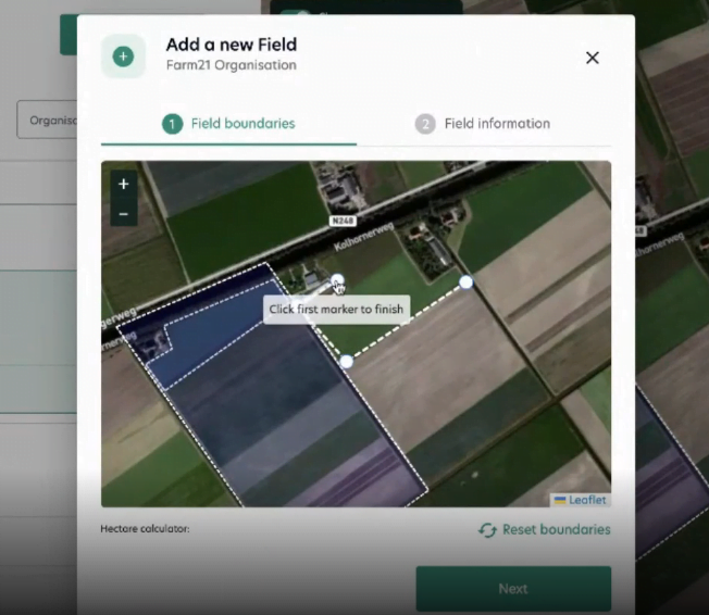
You can add an unlimited amount of fields to receive up-to-date information about that demarcated area. Adding fields can be done in seconds by drawing virtual field boundaries in a few clicks.
Satellite data
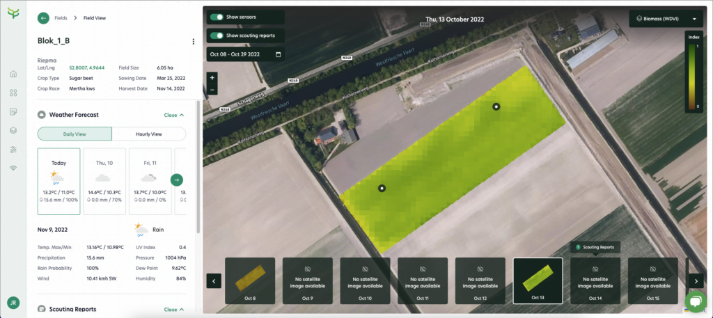
From the moment a field is added, current and historical satellite data is immediately available for that specific field, including NDVI, WDVI, NDRE and NDMI. (We’ll dive deeper into the different uses for satellite imagery later in this handbook.)
Weather data
We know that farming decisions are hugely weather-dependent. Accurate forecasts play a vital role in growers’ day-to-day planning and operations. Farm21’s platform provides accurate weather data with 1 to 11 km resolution. We select the best weather models for a specific area so growers, researchers, and crop advisors can better manage their operations – and with higher precision.
Sensor data
Our platform is designed to integrate seamlessly with the Farm21 soil sensors. To get the most out of our platform, we highly recommend adding sensors for complete data collection.

Users can easily access information on soil moisture and soil temperature at three different depths (-30cm, -20cm and -10cm) as well as accurate air temperature and air humidity below the crop canopy. Collecting local data allows users to know exactly what is happening with their crops. For example, a flower bulb grower from Holland used the data collected about air temperature below the crop canopy to take preventative measures against pests and diseases. (You can read more about that in the case study at the end of this handbook.)
To start collecting valuable insights with Farm21, simply start by creating an account. Fill in your organisation details, first name, last name and choose a password.
In summary, a good data platform can be extremely useful in the data collection phase. It can help access and track critical information regarding their crops. When deciding which platform to use, we recommend one with the following features:
- Affordable
- Easy to use
- Includes automatic warning systems
- Allows users to share data easily and for free
- Customisable data dashboard
- Combines information from multiple data sources
- API that can easily integrate with other platforms
As you can see, collecting the data is only the very beginning of precision farming. The next step is to access the data. So, once data has been collected, it needs to be processed in order to turn it into usable insights.
2. Accessing data
The second phase of the precision farming cycle, entails accessing the data that is collected in the first phase. To unlock the value from these metrics, it needs to be processed and turned into insights. Information from the various sources, including scouting, different types of sensors, satellites, weather stations and, of course, experience becomes more accessible and easy to interpret when it is categorised. With precision farming technology, ways to record data became more streamlined and processing data became much faster and more efficient. Digital platforms enabled users to see trends, and correlations and help to evaluate risks. In this part of the handbook, you will read more about the following:
- The best way to record and access data through scouting reports
- Three steps to create the perfect report (Find a suitable platform, record the correct information, and teach your team)
- Accessing satellite data and why it’s beneficial for farming operations
- Satellite imagery applications
- Types of satellite images and how they are used
The best way to record and access data through scouting reports
As mentioned in phase one, one of the first and oldest field data collection methods is scouting (or visual observation). Farmers would physically collect information by observing what is happening to their crops in the fields. Today still, it’s one of the most common practices for growers and their team members to gather data. By taking a closer look at the soil, leaves, flowers, trees, fruits, and vegetables, growers can gain valuable insights into the conditions of their crops and fields.
Although a lot of valuable information is to be gained from scouting, keeping a record of observations and accessing it when needed, is where the real value comes in. Being able to compare seasons, remind themselves what worked in the past and plan ahead can help growers to become more sustainable and more profitable.
Scouting report templates are made for growers to track their crops’ progress. It’s a systemised way to ensure everyone involved stays up to date with the latest developments while ensuring no information goes missing along the way.
With the digital revolution and the introduction of cell phones, where everything is quite literally at the tips of our fingers, scouting reports have moved online. Some farmers simply use WhatsApp to send their team or crop advisors scouting reports. Some use the Notes app, while others make use of something more formal, like a specific scouting app or farm management system.
Farm21 has been working closely with growers and crop advisors for more than five years. One of the most important things we realised during this time, is that it’s essential to have access to data that is all in one place, whether it’s soil moisture, cultivation plans, field boundaries, satellite images, scouting reports, or weather information.
We have put a lot of time and effort into building a data platform and app that includes all the information a grower needs to make the best farming decisions. Our goal is to save our clients time and money while helping to optimise their operations.
Three steps to create the perfect report:
- Find a suitable data platform for your specific needs
Before actually heading out, evaluate your fields with a suitable data platform. A good platform is one where you can learn as much as possible about your fields before leaving the office. Make sure you have these metrics in as many locations in the fields:
- Weather data
- Satellite information which includes NDVI, WDVI, NDRE and NDMI.
- Soil moisture
- Soil temperature
- Air temperature
- Air humidity
Using all this information, you can learn a lot about where to start scouting and what to look out for. Being prepared before the physical scouting begins can save a lot of time and effort.
- Add as much information as you can
Remember that your scouting report is going to be used by your team and crop advisor (now and probably in the future), so make sure you are adding all the information needed for others to understand exactly what the situation is. Add as many details as you can for the sake of completion.
A good, thorough scouting report should have the following information:
- Scouting Type: Growth, Pests, Water, Disease, Weeds or other.
- Description: What is it that you see and want to report
- Severity Level: High, Potential, Low
- Date
- Field name
- The exact location of the issue
- Photos – take as many photos as you can to show the issue
- A place to add more notes
- Teach your team
On some apps, you can share your scouting reports and other data sources with your team, so handbook them on what is a proper scouting report and what it’s essential information to include. Encourage them to be as detailed as possible and not to leave anything out. It is a great idea to have a consistent manner of reporting, that everyone sticks to, for the most comprehensive and valuable reports.
In summary, implementing an efficient scouting system and making the most of technology will ensure easy access to data when it is needed. This, in turn, leads to more data-driven decisions.
Accessing satellite data and why it’s beneficial for farming operations – click here to read more
Aside from providing more data sources (like satellite imagery and digital platforms), precision farming technology makes it easier than ever to access valuable information. Once data collected from the first phase is processed for easy access in the second phase, we can move to the third phase of the precision farming cycle — Using insights to make fact-based decisions.
3. Making decisions
In the third phase of the precision farming cycle, insights from phase two can help to make better-informed decisions. The hard work of gathering and interpreting data pays off in this part — Growers, crop advisors and researchers can use facts as well as a combination of knowledge and experience to bring new opportunities to the table. Better decisions regarding irrigation, fertilising, disease control, crop protection application, harvesting, and sowing can be made when the accurate details of fields and crops are known. One of the major benefits of basing decisions on facts is the efficient use of resources. In this part of the, handbook we dive deeper into the following topics:
1. How accurate soil data can be used to influence decisions
- Different soil types explained (sand, silt, clay, loam)
- An overview of water holding capacity of soil
- Water retention or pF-curve explained
- Watering regime and irrigation optimisation with the use of a pF-curve
2. Precision farming Checklist
How accurate soil data can be used to make the best decisions
Soil is a fundamental resource and a valuable source of information. Acquiring soil data, interpreting it and then making fact-based decisions according to those insights can help growers to apply resources optimally without compromising on yields. Before understanding how soil data can be used to benefit an operation, let’s take a closer look at different soil types:
Different soil types explained (Sand, silt, clay, loam)
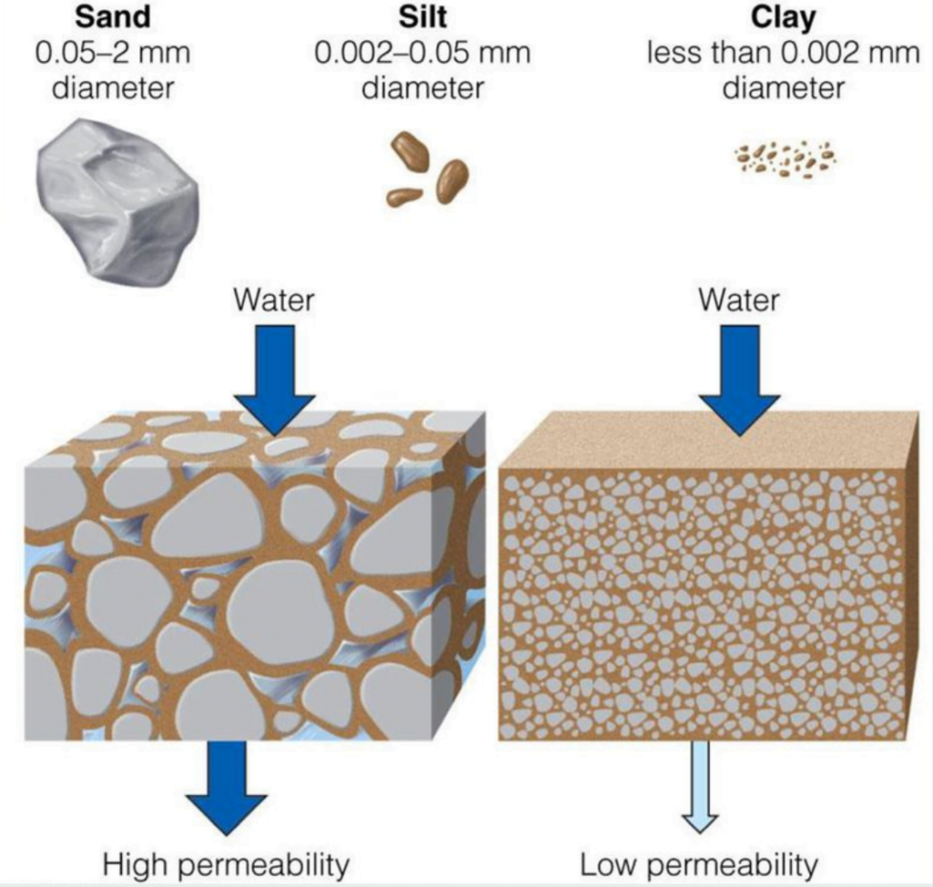
When it comes to classifying soil types, particle size is probably the most important factor as it dictates what the properties are. Soils are, therefore, classified according to their particle size into three main
SAND – 0,05-2mm diameter
SILT – 0,002-0,05mm diameter
CLAY – less than 0,002mm diameter
Sand
Sand particles are essentially small rock fragments, so no wonder it’s the soil type with the biggest particle diameter. Sandy soils feel gritty between the fingers and the sand grains have little ability to stick together. It is well known that sandy soils retain little water as a consequence of bigger spaces between the particles.
However, the water that is retained gets released to plants easily. When rain or irrigation occurs, water readily penetrates the soil surface, and the excess moves through rapidly and drains quickly.
SILT
The particles classified as silt are intermediate in size and chemical and physical properties between clay and sand. Silt tends to have a spherical shape, giving a high silt soil a soapy or slippery feeling when rubbed between the fingers when wet. Because of this spherical shape, silt also retains water easily, and it releases the water readily to plants.
Silt is generally considered good for the growth of plants, largely due to its water-holding capacity.
CLAY
Clay is made up of the finest particles out of all the soil types. When a small sample of clay soil is wetted and rubbed between the fingers it will feel sticky. Clay is excellent at retaining water and many plant nutrients such as calcium, magnesium, potassium, trace elements and phosphorus. A mixture of soil without clay particles tends to be infertile. Although clay retains water really well, it does not release the water as readily as other soil types.
Clay particles have a much greater tendency to stick together than sand, thus it is common farmer knowledge that soil high in clay is difficult to till.
In practice, most fields consist of a mixture of the above soil types. Since there can be an infinite array of percentages of sand, silt and clay in soils, scientists have standardised a procedure for classifying the potential combinations into 12 groups to reflect broad soil properties. These groups are called textural class names and are obtained by applying the particle size analysis to a textural triangle:
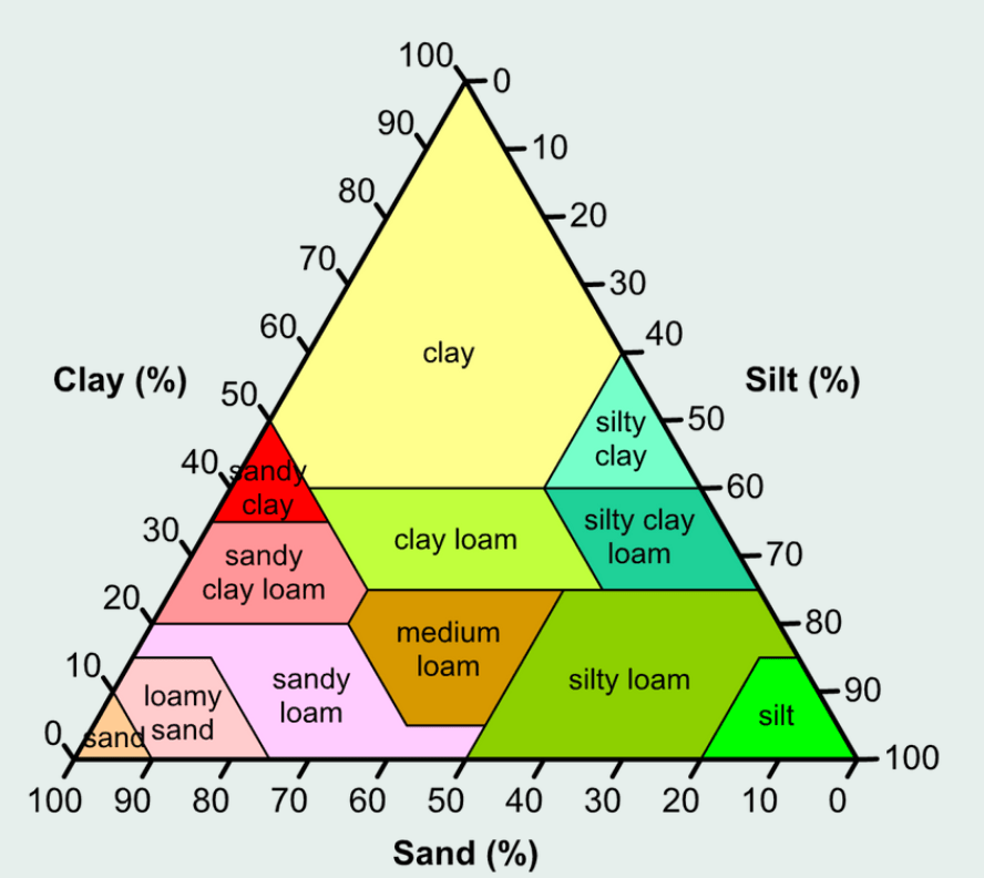
LOAM
For example, loam soil is the best-suited soil type for growing most plants due to its propensity for holding enough water and nutrients, yet releasing it relatively easy too. As opposed to clay-dominant soils which, although rich in nutrients, have poor drainage due to the small pore size and are not ideal for roots to grow in due to its hard packed texture. Sandy soils do not hold water well, and silt does not hold nutrients well. By offering a mixture of these particles, loam accentuates the benefits and balances out the detriments of each particle size, forming a fertile medium which is the ideal soil type for many plant types.
An overview of water holding capacity of soil
As we mentioned earlier, the size of the particles and the spaces between them are essentially the determining factors of a soil’s water-holding capacity. The image below shows the spaces between particles – and it is called “pores”. Macropores can store a lot of water and it’s easily accessed by the plants, but they cannot hold the water very well. With micropores, it’s the exact opposite.
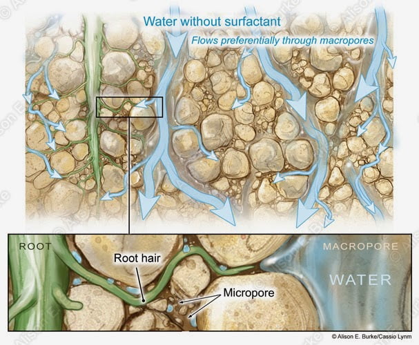
Taking a step back and looking at what is happening on soil’s surface, we’ll see that when a plant loses water through its leaves (called transpiration), it creates a pressure difference. This pressure difference leads to suction tension allowing roots to draw water from the pores in the soil to restore the balance. Roots extract water more easily from macro pores, which means there is less suction tension needed.
Water retention or pF-curve explained
The pF-curve essentially shows how easily plants can access water in the soil. This accessibility differs per soil type, but with the right instruments, the characteristic pF-curves can be determined for each. (For example, you could use a tensiometer to determine the soil suction, also called: soil potential). These curves relate the soil suction,or how tightly moisture is held in the soil, to the volumetric water content in the soil.
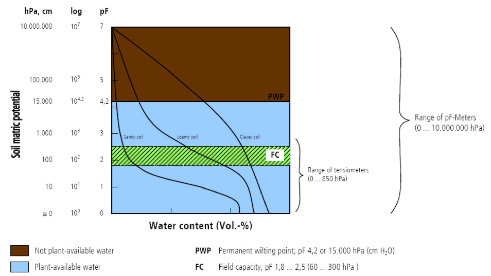
Suction is shown on the y-axis and measured in hPa. VWC is shown on the x-axis and is the percentage of water per soil unit.
In clay soil for example, higher suction is needed to get water out when compared to sandy soils where much lower suction is applied to get the same amount of water out. In short, clay soils can hold more water, but it also holds the water tighter which requires higher suction to access it.
Watering regime and irrigation optimisation with the use of a pF-curve
In order to understand how to optimise your watering regime by using the pF-curve, it is vital to understand what is meant by the following:
- Saturation: During a rain shower or irrigation application, the soil pores will fill with water. If all soil pores are filled with water the soil is said to be saturated, meaning there is no air left in the soil. Plants need both air and water in the soil.
Hence, when at saturation, no air is present the plant will inevitably suffer. Many crops cannot withstand saturated soil conditions for a period of more than 2-5 days. Rice is one of the exceptions to this rule. The period of saturation of the topsoil usually does not last long. After the rain or the irrigation has stopped, part of the water present in the larger pores will move down — This process is called drainage or percolation. The water drained from the pores is replaced by air. In sandy soils, drainage is completed within a period of a few hours. In fine clayey soils, drainage may take around 2-3 days.
- Field capacity: After the drainage has stopped, the large soil pores are filled with both air and water while the smaller pores are still full of water. At this stage, the soil is said to be at field capacity. At field capacity, the water and air contents of the soil are considered to be ideal for crop growth.
- Refill point: This is somewhere between field capacity and wilting point. It’s the point where the crop is starting to experience stress. From this point to wilting point (when the crops die), crops are suffering and the yield will subsequently be limited.
The refill point differs for different crop types and also depends on its phenological state.
- Permanent wilting point: Little by little, the water stored in the soil is taken up by the plant roots, darined to deeper layers or evaporated from the topsoil into the atmosphere. If no additional water is supplied to the soil, it gradually dries out. The dryer the soil becomes, the more tightly the remaining water is retained and the more difficult it is for the plant roots to extract it. At a certain stage, the uptake of water is not sufficient to meet the plant’s needs. The plant will inevitably wilt, and leaves change colour from green to yellow. Finally the plant dies.
The soil water content at the stage where the plant dies is called permanent wilting point. Although the soil still contains some water, it is too difficult for the roots to suck it from the soil.
Precision Agriculture helps growers to manage watering regimes with much more accuracy. Once the volumetric water content for field capacity has been calculated, it can be kept at optimum levels with the help of soil moisture sensors. Accurate readings from soil moisture probes help to determine when to irrigate, and gives a clearer picture of how much to irrigate.
Farm21 has developed a water risk assessment tool — We calculate the water retention curve of a specific soil type (as a combination of sand, silt, clay and organic matter percentages). As water availability becomes limited, the risk of moisture stress rises, which is translated into a risk level so that growers can always be one step ahead and keep soil moisture levels at an appropriate level.
So, how does this work in practice? Martijn Slabbekoorn from Slabbekoorn Fruit in The Netherlands used Farm21’s soil moisture sensors and data platform to optimally manage his irrigation regime (which ultimately resulted in an increased yield). Martijn wanted to keep the soil tension around 70-80 KPa for optimal fruit growth. He calculated this to be 11% volumetric water content in sandy soil and 40% volumetric water content in loam clay soil. With the use of the FS21 sensor, he maintained this through precise irrigation. (You can find the full case study at the end of this handbook.)
In summary, when decisions are based on facts, rather than estimations, it is possible to make use of resources more efficiently. Precision agriculture has provided a variety of tools to gather and interpret information from the soil that can be used to make fact-based decisions.
Precision farming checklist – click here to download
Once the third step of making decisions is completed we are ready to implement these decisions in the fourth and final phase by taking the correct in-field action.
Taking action
Accurate data has been gathered and translated into valuable insights to base decisions on facts. Now, it is time to take the relevant in-field actions in the fourth and final stage of the precision farming cycle. Taking action with a focussed approach, means resources can be applied where necessary, at the right time in the right quantities. It also helps to shift the operation from reactive to proactive, so growers, researchers and crop advisors can be one step ahead, anticipating problems before crops are damaged. In this part of the handbook, you will read about the following:
- Water management tools and tips for taking the best course of action
- Why farmers are turning to precision agriculture tools to optimise water usage
- The advantages of precision water management
- The best agricultural tools to help optimise watering action
- Case study examples
- Taking action based on soil moisture to increase broccoli yield
- Taking action based on soil moisture to optimise fertigation for apples and pears
- Taking action to prevent pests from causing harm to flower bulbs
Water management tools and tips for taking the best course of action – click here to read more
Case study examples
The following are real-life examples to show how growers took the relevant in-field action. After gathering information in the first phase and translating it into usable insights, they could make data-driven decisions that ultimately benefited their operations.
Taking action based on soil moisture to increase broccoli yield
Taking action based on soil moisture to optimise fertigation for apples and pears
Taking action based on temperature to prevent pests from causing harm to bulbs
In closing, it’s important to note that the experience that comes from taking the relevant action, then becomes another data source and the cycle starts all over again. Growers, researchers and crop advisors are continuously learning and Precision Farming tools can aid in making better decisions year after year.
Conclusions and recommendations
As you have learned in this handbook, Precision Agriculture consists of performing the right operation, in the right place, at the right time, in the appropriate manner, and in the right amount. To achieve this, you must start by gathering accurate data and translate this into valuable insights on which to base your decisions so that, ultimately, you can take the best course of action.
Are you ready to take your operation to the next level?
Let’s grow together!
At Farm21, we are committed to developing tools that help our clients get the most out of their fields. A combination of technology, hardware and software and expert advice makes us the ultimate precision farming partners.
We would love to hear from you and tell you more about our product offering at Farm21. Please visit our website at farm21.com or email us [email protected].
